 |
 |
 |
 |
||||
 |
 |
 |
 |
 |
SALGA NEWS |
Upcoming Events |
 |
|
|
|
|

|
|
Annual Report |
 |
Quick Links |
|
|
|
|
Municipalities |
 |
|
|
Social Media |
 |
Follow Us on Social Media
|
|

A Best Practice: GSDM on the practical implementation of 4IR
Posted: 17 May 2021
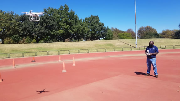 |
Image 1: Mtha’ Mkhonza, GM for Planning and Economic Development and champion for innovation at Gert Sibande District Municipality preparing for his CAA drone pilot practical test. He is one of the six pilots at GSDM
Gert Sibande District Municipality is one of the three district municipalities in Mpumalanga, and further houses the most local municipalities namely; Dipaleseng, Chief Albert Luthuli, Dr Pixley Ka Isaka Seme, Govan Mbeki, Lekwa, Mkhondo and Msukaligwa.
Due to the vastness and the rural nature of the District, the introduction of more innovate and efficient ways to pave a development trajectory has always been in the heart of the Spatial Development Framework (SDF) and other sector plans that are aligned to the SDF. Bearing in mind that in most of the aforementioned Local Municipalities’, the practical use of 4IR innovations has put the district on the right path in response to tackling the triple challenges that continue to plague South Africa as a whole.
The District municipality is also one of the few municipalities that has managed to tap into the use of the grant, namely the Infrastructure Skills and Development Grant (ISDG) )which aims to ensure that young professionals are placed in its municipalities’ and further guarantee that these young professionals are certifies as professionals in their field of study.
Background
Local government is performing a variety of functions that have been historically performed using manual, time consuming and costly methods. In some instances local government is unable to perform critical functions due to unavailability of technology or skills. This leads to either functions being dangerously or inadequately performed, not performed or outsourced at a higher price.

Image 2: GSDM Office complex from a drone Ariel view
Differentiated roles and responsibilities of Drone capabilities
This section will delve further in to the roles and capabilities of drone technologies through some examples are as mentioned in the points enlisted as follows:
- Drone imagery in fire fighting

Thermal imagery in from a drone depicting heat sources guide fire fighters in their fire fighting and rescue mission planning avoiding and minimizing fatalities. The Municipal Structures Act (2000) (84) (j) mandates Districts to perform specialized fire fighting services such as chemical, veld and mountain fire fighting. These require specialized tools and applications such as those available in drone capabilities.

- Gas Detection and Monitoring
Drones are used for monitoring gas emulsion in various emitting points using thermal imagery from drones. As an air quality authority, drone capability will greatly improve our capability to monitor gas emissions and regulate the air quality the GSDM jurisdiction. The GSDM is in the process of procuring a quadcopter drone capable of carrying payload capable of detecting methane gas in the atmosphere. This will enhance the capabilities of the air quality management unit in execution its legislated functions

- Drones in Contour Mapping
Contour mapping is the foundation for all township design as it profiles the slope of a site in order to determine suitability for development and flow directions for storm water flow and water reticulation networks. Drones perform this function quicker and cheaper than manual surveying. This is another government function that is always outsourced to the private sector.

- Drones in Infrastructure assessment
Drones are used in the assessment of the structural integrity of various infrastructure assets ranging from electricity cables, electricity transmitters, roads bridges etc. Manual assessments of these assets is dangerous and sometimes impossible leading to failure to detect early warning signs for maintenance requirements.

- Bridges assessments: underpasses, overpasses and culverts, for cracks, wear and general conditions.
Some parts of strategic infrastructure may be difficult for engineers to reach manually therefore making it difficult to assess them for structural integrity. Drone footage bridges this gap and limit the safety risk on assessors and users of the infrastructure.
Progress to date
Legal requirements:
- Pilot licences: 6 GSDM staff trained and are now certified by the CAA
- Institutional Licence (ROC) : Air service licence gazette published for published participation; CAA application to be lodged after air service licence approval
- Drone licence: Application to be lodged after air service licence application
- Two drone technicians undergoing training for care and maintenance of drone fleet.
Conclusion
The work that has already been done by Gert Sibande District Municipality is very commendable because it truly depicts that the District is taking charge of developmental planning and its counterparts should also follow suite. The examples that have been aforementioned are merely pieces of a larger spectrum of what this type of technology can do and how it can be used by municipalities.